A high alpine cross country loop that passes through several meadows.
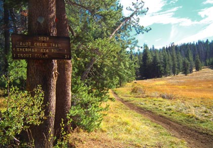
At the trail junction in Corral Meadow. |

THE STATS
- 11+ Miles
- Loop
- Elevation Range: 7800-8800 ft
- Motorized Multi-Use Singletrack
- Land: Sequoia National Forest
- Access: Sherman Pass Rd. Kennedy Meadows, Kernville
- When: Summer, Fall
- Best: after Rain
- Map: Kern River Sierra Outdoor Recreation Map, 6th ed
|
The Ride
Passing in and out of the forested canopy through Boone Meadow, Corral Meadow, West Meadow, Bonita Meadows, and Curliss Meadow, this ride consists of almost all singletrack. The "High Meadows Loop," a.k.a. Bonita Mdw Loop, is a beautiful and rewarding high alpine cross country ride that weaves throughout the 7800ft to 8800ft elevation range. Its a great way to escape the heat of summer, and get a solid pedal in. Part of this ride is used to access the Cedar Canyon Trail also.
The area sees a fair amount of motorcycle use, so expect to see a couple riders. Most of the trail quality is good, with a few exceptions. OHV funds provide for trail maintenance and a trail machine to flatten the "whoops" that form in places.
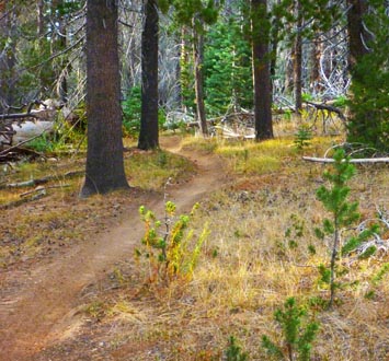 |
Perfect singletrack waiting for a mountain biker.
|
The Details
The loop rides best when pedalling in a clockwise direction.
Ideally, you start with Boone Meadow Trail and descend to Trout Creek near Boone Meadow.
From here, turn right and climb Trout Creek Trail. Cross Sherman Pass Road and continue. At Corral Meadow turn right on Schaeffer Trail, which climbs over a pass and drops down to West Meadow. You'll merge onto a road for awhile (stay right), and look for the trail continuing on the right.
Follow the "Trail" (33E24) signs to Bonita Meadow. Soon you'll meet up with Beach Meadow Trail (34E01). Go right on this trail (south), and return to the start.
Note that there are several other road and trail crossings throughout the ride.
Trailhead
From Kernville, the trailhead is 1-1.5 hour away. Drive up Mtn 99, then turn right before the Johnsondale Bridge onto Sherman Pass Drive and go up to the Sherman Pass Lookout. If you want to add a few miles and some extra downhill/climbing, you can park here (Sherman Pass / Cannell Trailhead.) Take Sherman Pass Trail down and turn left on Trout Creek Trail for the loop.
Another option is to drive beyond Sherman Pass downhill and park near Trout Creek Trail crossing.
For an ideal ride that does not end with a big climb, drive further (4.5+ miles past Sherman Pass) and look for Boone Meadow Trail descending on the right. Park and start the ride near this spot.
Nearby Activities
- Go BikePacking
- Bike Sherman Peak, Sherman Pass, Cannell Trail, Cedar Canyon, Beach Ridge Trail, Fish Creek, Jackass
- Rock Climb Spirit Rock, Ghost Rock, Sherman Pass Crags: Trout Rock, Boone Rocks, The Beach
- Hike (or Canyoneer) Durrwood Creek, Lookout & Shcaeffer Mountains, Granite Knob, Smith Mountain, Sherman Peak
- Domelands: Manter Meadow
- Hike or ClimbTaylor Dome & Church Dome & Rockhouse Peak
- Raft, Kayak, or SUP the Kern River
- Dirt Bike 100's of miles of singletrack trail
- Backpack Domelands or Golden Trout Wilderness
|

