Hike a difficult & remote off-trail route beyond the Rincon Trail for close up views of the waterfalls. For experienced adventurers only!
|
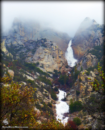
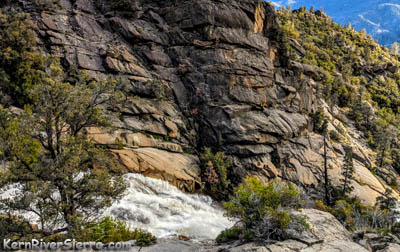
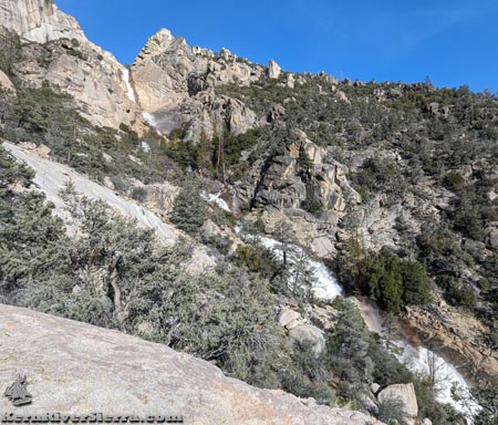
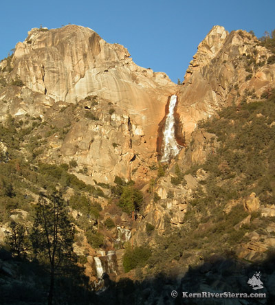
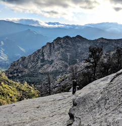
Above: Salmon Creek Middle and Upper Falls. Hiking during a huge rain storm for maximum drama!
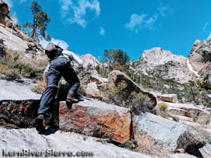
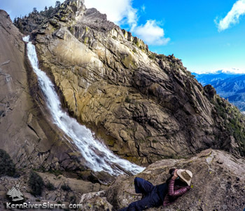
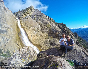
Right: Celebrating at the top of the "Viewpoint Knob". |
THE STATS
- Miles: 7+ mi roundtrip
- Elevation Gain/Loss: 3200+ ft
- Hike: Up & back, on & off-trail
- Class: 2-3+, lots of scrambling
- Note: Route-finding & strong outdoor skills required
- Rincon Trail: Motorized Multi-Use
- Wild Route: Brush, Steep Slopes, Granite, Cliffs, Ledges, Boulders, Slippery Rock, Waterfalls
- Elevation: Trailhead 3600 ft; 4500 ft at Bridge; Viewpoint Knob at Upper Falls: 6300
- Land: Sequoia National Forest
- Where: Between the Kern River & Kern Plateau
- Access: Kernville
- Map: Kern River Sierra Outdoor Rec Map
|
Salmon Creek Falls
 |
Less than 1/2 mile above Rincon Trail. |
Click here for a full Description of the 450 foot Salmon Creek Falls and the access via Rincon Trail. This route picks up from the Rincon Trail 1/3 mile above the Salmon Creek Bridge and scrambles rough terrain up to the Middle and Upper Falls area.
The highlight is hiking to a "Viewpoint Knob," which sits directly in front of the falls in an amphitheater of huge walls of granite. To the west are wide open views of Ant Canyon and the Greenhorn Mountains.
On the way to the Knob, the Route passes another great destination: the large granite slab across from the "Middle" falls.
Amazing views are seen throughout the entire hike!
Note: This is not the USFS named "Salmon Creek Falls Trail," which starts near Horse Meadow and ends above the upper falls. However, they could be linked with a lot of effort. That hike is described here.
Adventure Hiking on a Wild Route
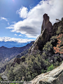 |
This towering spike rock is a landmark for the final approach. |
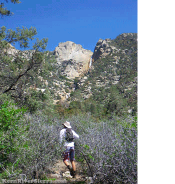
After hiking part of the Rincon Trail, the sight of these impressive falls might invoke that yearning itch of wanderlust in spirited adventurers.
If so, the full-body cliff-clinger scrambling will be so worth it! Hiking up to the waterfall is an unforgettable but demanding nature experience. Route finding skills are critical to this hike; there is no official trail but it is well cairned.
There is an exceptional viewpoint directly in front of the falls, where a steep rock fin juts out of the granite wall on the northwest side of the waterfall and creates a jagged knob.
Getting there requires hiking off trail at least an additional 1,700+ vertical feet in 1.2+ miles. Much of this wild route hike is class 2-3, sometimes with exposure, and requires a short class 3-4 move to reach the top.
Along the way, there are outstanding viewpoints on rock outcrops, and an inviting rock slab near the Middle Falls. Any of these are worthy destinations as well.
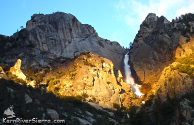 |
Upper Salmon Creek Falls. The final approach is between the lit up spike rock (on the left) and the Viewpoint Knob (to the right). Salmon Creek Wall towers above. |
The "easiest" route steeply traverses the slope on the northwest side of Salmon Creek, and avoids a mess of extremely brushy hills and endless gulleys closer to the creek.
As of Spring 2023, there is a relatively cleared and cairned (stacked rocks) route that is extremely helpful to follow. It avoids brush (except for some grass and small ground plants) and is fairly easy to follow for the first half mile. After this, the route encounters more boulders and granite slabs for much of the way.
Preparation
 |
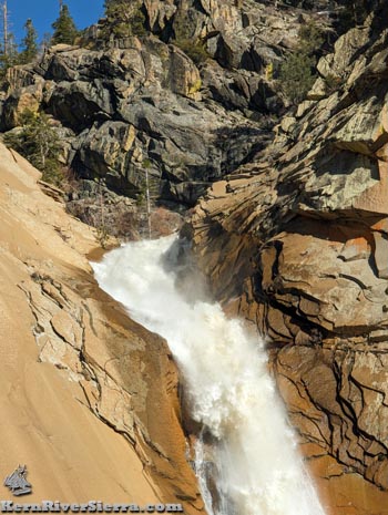
Part of the huge slide by Middle Falls. |
This is center stage to nature's drama, but this incredible hike to the Knob is for real: sticky rubber shoes, both technical climbing, strong outdoor and route-finding skills, and possibly a small rope, could all be very helpful on the upper sections of the hike. Its also usually much colder at the top with some windy mist in the spring; dress accordingly.
Because of all the scrambling along, through, under, and over rock and log obstacles, it is far more physically demanding than the stats suggest. The steeper exposure in the upper sections deter many people. Considering the remoteness and extreme nature of this hike, prepare appropriately.
Hiking Details
Start on the Rincon Trail, described here, hiking about 2 miles from the trailhead.
 |
 |
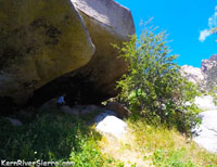
The Boulder Cave. On the left photo: The "trail" comes up the clearing into the cave. Walk through the cave, and the route continues in the direction of the falls, seen in the upper left corner. |
The Wild Route turns off Rincon Trail .3 miles past the Salmon Creek Bridge, near a grove of pine trees. Look for a cairn ( still there Spring 2023) and a "use trail" leading through the bushes. Photo of here.
 |
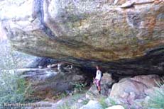
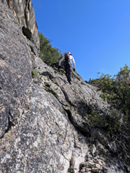
Rough Terrain! The hiker is standing in between the two main ledges at the waterfalls/streaked creek. |
The route initially weaves through some trees and brush before veering left up a gulley. The route soon turns right up the hillside, and undulates through small ravines. Within about 1/4 mile, it leads directly into a gigantic boulder on the slope that creates a large overhanging cave. On one trip the authors spooked a bear at this cave! From the cave you can see the upper falls.
From inside the cave, the route aims for the falls, drops through a ravine, then turns right and flatly contours the slope for a little bit. Once around the corner, it then starts climbing through boulders, which progressively get steeper. It passes down through a few gulleys along its way. The views keep getting better!
Roughly half way up, the route comes to a small creek with waterfalls (during spring melt) or water streaks later in the year. The route brings you to a bouldery spot between two main ledges that create the falls/streaks. Cross here.
Scramble up the right side of the small creek bank following cairns. After a short steep climb, there is a little pathway through some oak trees after which the route climbs over another boulder. Climb up the hillside to the right of a granite slab, and look for another passageway through oak trees at the side of a huge boulder. Continue traversing south toward the creek and the route pops out at a large sunny slab across from the Middle Falls.
The beautiful area near the granite slabs by the Middle Falls/Slidesis the final destination for many people. The hike steepens and the terrain roughens from this point on.
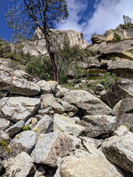
Above: The granite slabs near the Middle Falls/Slides. Right: Same area zoomed in. |
 |
A maze of trees and boulders awaits as the cairned route continues from the slab up a small ridge before dropping down to cross a valley with an old downed tree. Climb up the other side and though some trees to the edge of another granite slab.
Keep climbing up the various granite slopes, occasionally moving in and of the forest to avoid steep rock. The Viewpoint Knob will come into better view and eventually blocks sight of the upper falls. The goal is to hike up a long steep chute of boulders between "The Knob" formation and a striking spike-like tower rock formation on the left (shown in photo above). Go to the top of the boulders and traverse the sloped granite on the right. (There are some options here).
The Knob is approachable from the northwest and requires crawling up through one of the rock chimneys to reach the high point. It's easiest to go higher, but still requires a technical move or two with a bit of exposure. (The usual approach chimney has a small oak tree in it, which can be used as a foot hold.)
Once you make it through, the sudden view that opens up will take your breath away. See it to believe it!
If its hot, enjoy the breeze and myst coming off the falls.
 |
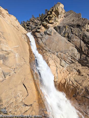
2,000 feet above the Rincon Bridge. Photo taken from "The Knob" viewpoint described below. |
If you look closely, there are bolts and quickdraws left from canyoneering adventures on the creek, and an attempted rock climbing route up the huge rock wall on the north side. More climbing info and photos are here.
Options
From the Knob, one can hike the steep slope down to the water on the other side and explore around.
It's also possible to climb to the base of the giant wall, or up the saddle to the north, by continuing up past the long boulder chute. There are some camping options at the top, and one could connect to the USFS Salmon Creek Falls Trail near the upper Teacups.
 |
 |
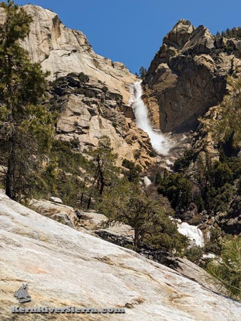
| The top of the falls. Just below a series of "Teacups" near the terminus of the USFS Salmon Creek Falls Trail. |
The 450 foot Salmon Creek Falls. |
Trailhead & Directions
Drive 10 miles north of Kernville on Mtn 99 to to Ant Canyon. There is a signed 4x4 road that ascends to the trailhead here. However, its best to drive another .8 miles on Mtn 99, and turn right on the aqueduct road that is signed "salmon."
At the first intersection (with the Rincon 4x4 road), make a ridiculously sharp left turn. At the next junction, turn right and follow this road. Look for a road ascending to the left, which leads to a small parking area at the Rincon Trailhead. Most of these roads are signed.
The hike begins with a short climb up an old 4x4 road, and the route soon veers off to the right. Happy Trails.
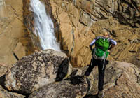 |
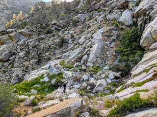
Exploring the different
vantage points. |
 |
| Beauty seen from Rinvon Trail. |
Nearby Trails & Activities
|
